
Reading Skjervøy history across the islands
Skjervøy history extends beyond the main village and its harbour. The municipality lies entirely on islands between the mouths of the Kvænangen and Lyngen fjords, while the administrative centre stands on Skjervøya. Keeping that distinction in mind makes the cultural map easier to read: a church in the village, a former trading place on Kågen and a trail on Laukøya are separate destinations.
The municipality was established in 1837. Nordreisa separated in 1886, and further boundary changes followed in 1965 and 1972. These dates describe the administrative story rather than the beginning of life in the area. For a visit, use them as a framework alongside the older church and the island sites that show different aspects of coastal history. Begin with the Skjervøy overview if you need to place the islands before choosing a route.
Things to do around the church and cultural places
Skjervøy's existing wooden church dates from 1728. Its form sits between a long church and a cruciform church, and the present onion-shaped tower was added in 1777. Those distinct building dates give you something specific to notice in its outline. The building is protected, with strict restoration requirements, so it is also a reminder that historic architecture remains part of a living community.
The church history links its construction to the missionary work of Thomas von Westen and names the Kven master builder Hans Michelsen. Norwegian, Sami and Kven people from the surrounding area formed part of the congregation. Approach that account with respect for the communities involved and for the difference between a historical mission and today's cultural identities. If you want an interior visit, check the arrangements for the church itself; parish office hours concern office business.
Our picks: boat trips
Hand-picked tours, booked through GetYourGuide. Prices are indicative starting prices in euros (as of October 2026). Tap a tour for live availability and the current price in your currency.

RIB safari with bus from Tromsø
- Transfers to Skjervøy
- Thermal protective suit and life vest
- Hot drink and sandwich
A skipper accompanies the boat trip; boots, mittens and goggles are provided.
Check availability →
RIB whale watching from Skjervøy
- Thermal suits and life vest
- Mittens and goggles
A guide accompanies the boat trip.
Check availability →Plan a separate outing on the water
Combine your cultural visit with the coastal and wildlife experiences covered in the boat guides.
Sami, Kven and Norwegian coastal culture
The area's cultural history reflects the interaction of Sami, Kven and Norwegian populations. Place names, language and traditions are useful ways to understand that shared regional context. Avoid reducing it to a single costume, activity or historical label. A visit to the church and the wider cultural landscape can introduce these connections without treating people as an attraction or suggesting that one excursion represents all local identities.
Spread cultural stops across the actual islands in your plan. A place listed within Skjervøy municipality may require onward travel from the village. This is particularly relevant if you arrive by boat and have only a short window on land. Consult the arrival and island transport guide before combining a cultural site with accommodation or a separate boat departure.
Maursund on Kågen and other island sites
Maursund gård is on Kågen, within Skjervøy municipality. The former trading place brings together agriculture, fishing, commerce and shipping in the regional account of its past. It gives a different perspective from the church: consider the work and transport associated with a coastal trading place as well as the buildings themselves. Arrange any intended museum visit around the opening information for your date.
The regional cultural overview also includes Seppalatunet and the cultural trail on Laukøya beginning at Nikkeby. Treat these as individual places when choosing an itinerary, with their own access arrangements. An island trail and a museum visit require different practical preparation. Choose the places that fit your available travel time instead of assuming that all the municipality's cultural sites form a single village walk.
Engnes and Stussnes: walks with different purposes
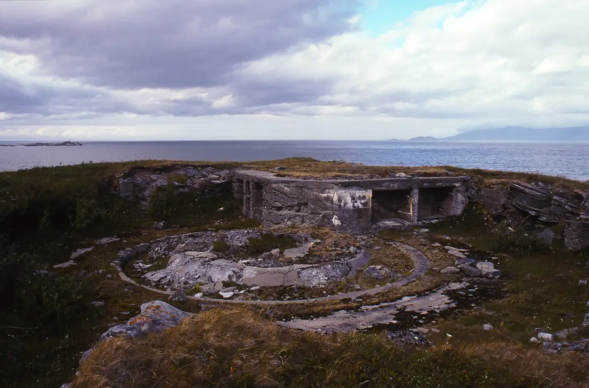
The Engnes route starts at the sports ground on Skjervøya and follows an old road towards the island's northern tip. Remains of a German coastal fort from the Second World War connect the walk with wartime history. The described return route is 7 km. Choose the route variant that matches your day and conditions; keep your visit focused on the coastal landscape and visible remains.
Stussnesfjellet is a separate walking option, approached by Rypevegen and a gravel path. Its route description gives 2.6 km and a high point of 161 m. The described summer suitability for pushchairs and electric wheelchairs should be considered within its seasonal context. Snow, ice and darkness require a fresh assessment, rather than a transfer of summer expectations. The season guide helps place these walks within your broader plans.
A harbour stop and time for culture
Skjervøy is a Hurtigruten port of call with a short stay. Treat a passing harbour visit as a different format from a planned cultural day. If the church, Kågen or an island trail is central to your interests, choose transport and accommodation around that aim. Leave time for the journey between places and keep any wildlife outing as a separate activity.
Questions for your visit
When was the wooden church built?
The existing church dates from 1728, while its present onion-shaped tower was added in 1777. These refer to different stages of the building.
Is Maursund in the main village?
Maursund gård stands on Kågen. Plan it as a separate destination from the church and harbour on Skjervøya.
Can I combine Engnes with a cultural visit?
Engnes combines a coastal walk with visible Second World War fort remains. Select the route and assess conditions for your day, especially when snow, ice or limited daylight affect walking.